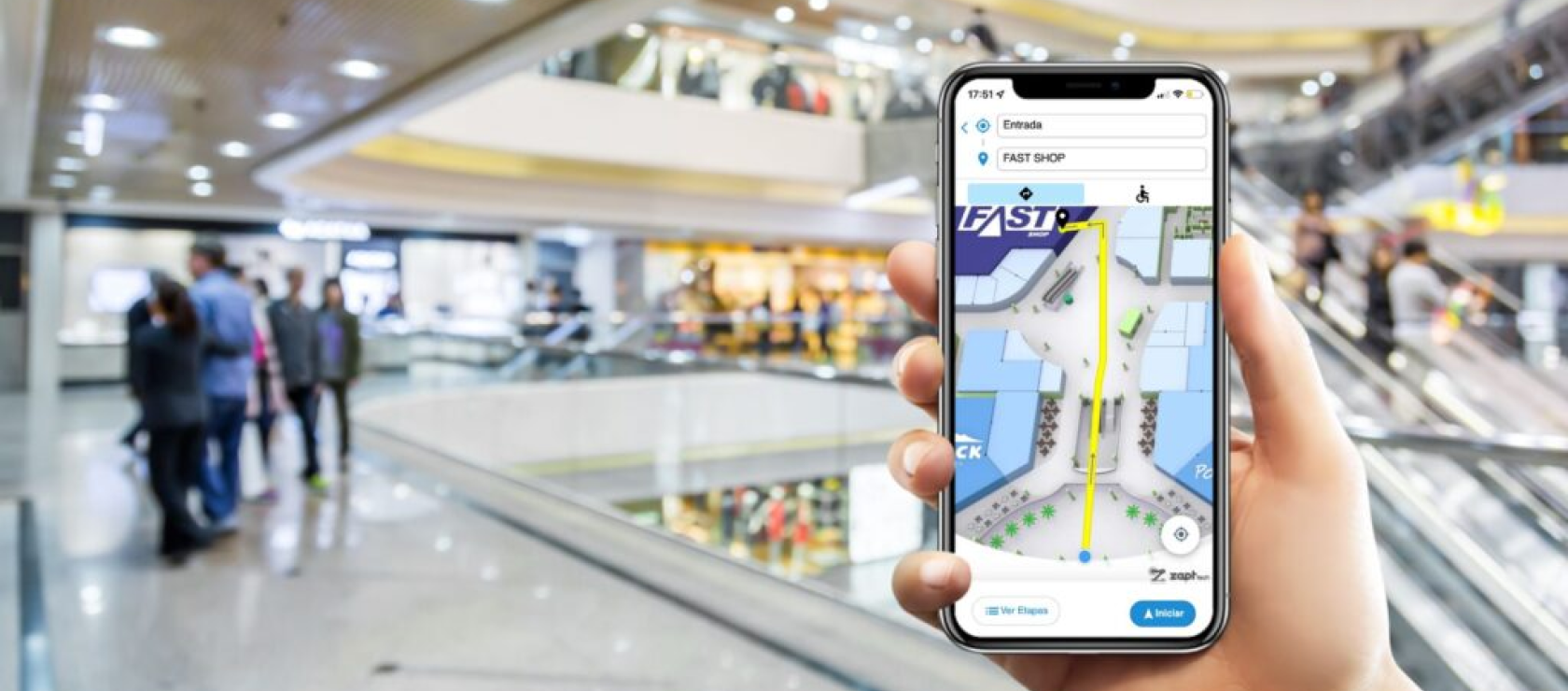
Do you plan to develop an indoor navigation app for your business?
Just like having a knowledgeable guide, indoor navigation apps make it easier for people to find their way around busy places like shopping malls, hospitals, airports, and office buildings.
Regularly ranked among the Top Custom Software Development Companies on Clutch, our team at Volpis has spent years building custom indoor navigation apps for companies worldwide. In this article, we want to offer a comprehensive overview of the steps involved in developing an indoor navigation app.
And if you have any questions or concerns after reading this article, please don’t hesitate to reach out to us via info@volpis.com
How to develop an indoor navigation app: step-by-step process

Unlike outdoor navigation, which relies on GPS technology (global positioning system), indoor navigation system requires different technologies to deliver accurate, real-time guidance. In this guide, we’ll take you through the steps to create a successful indoor navigation app that caters to different users in various environments. Whether you’re developing a navigation tool for a shopping mall or creating an easy-to-use guide for a hospital, this guide’s got your back to make sure your customers have a great experience.
Step 1: Creating or acquiring a floor plan
An accurate floor plan is crucial for developing an indoor navigation application. It serves as the foundation for mapping the building’s layout, including rooms, hallways, doors, and points of interest (POIs). Whether you start with a paper plan or need to create floor plans for multiple levels, the process involves converting these layouts into digital formats suitable for navigation.
| Phase | Process |
| 1. Digitize your paper floor plan If your current floor plan exists in a physical, paper format, you can still transform it into a digital map that works with indoor navigation system. Follow these steps to convert your paper plan: | Scan the paper plan: Use a high-resolution scanner to digitize the paper plan, saving it as an image file (JPEG, PNG, or PDF). The higher the quality of the scan, the more accurate your digital map will be. Import the scanned image into a design tool: Load the scanned image into a design tool such as AutoCAD, ArcGIS, or any other mapping software. These tools allow you to trace the layout and recreate it in a digital format. Digitally redraw the floor plan: Use the software to trace the layout, carefully marking key features like walls, doors, rooms, and hallways. Include important elements such as stairways, elevators, windows, and POIs (e.g., restrooms, fire exits, or emergency equipment locations). Clearly label rooms, corridors, and any significant features to ensure accuracy in navigation. Georeference the floor plan (optional): If you plan to integrate the map with outdoor navigation or real-world positioning systems, align the digital map with a specific coordinate system. Georeferencing ensures that locations on the map match their real-world counterparts. |
| 2. Handle multi-floor layouts When working with a building that has more than one level, each floor needs a separate map that integrates seamlessly into a multi-floor navigation system. Here’s how to handle multi-floor mapping: | Create or obtain separate floor plans for each level: Draw or import individual 2D-floor plans for each floor. Make sure that all important features (e.g., rooms, doors, POIs) are included. Use a consistent approach for all floor plans to maintain uniformity across different levels. Identify vertical transition points: Mark all vertical transitions such as staircases, elevators, and ramps on each floor plan. Label these transitions clearly as they will be used later to connect different floors within the navigation system. Georeference each floor plan (optional): If needed, ensure that each floor plan is georeferenced with the same coordinate system. This allows for accurate positioning and smooth transitions between floors. Link the floor plans: Use design tools to connect the individual floor plans, representing vertical transitions with “transition nodes.” These nodes are points where users can move between different levels, such as staircases or elevators. Ensure that the connections are accurately mapped, taking into account any unique features or accessibility requirements (e.g., ramps for wheelchair access). |
| 3. Prepare your floor plan for digital mapping Once you have created or acquired the floor plans, they need to be prepared for integration into the indoor navigation system. This step involves converting the plans into formats suitable for digital mapping, such as GeoJSON, SVG, or CAD. | Digitize and vectorize the floor plan: If starting with a scanned image, ensure that the floor plan is vectorized within the design tool. Vectorization transforms the map into a scalable format and enables data extraction for features like room shapes, door locations, and hallway connections. Layer the map elements: Separate various components of the map into distinct layers for better organization. For example: rooms can be one layer, hallways and doors can be another, and stairs, elevators, and other amenities can be additional layers. These layers allow for dynamic toggling within the navigation app, providing users with an interactive indoor map. Add attributes to map features: Assign relevant attributes to different elements, such as room names, floor numbers, or POI types. These attributes help the navigation system provide users with context-specific information, such as which floor a room is on or the location of the nearest restroom. Georeference the entire building (if applicable): For multi-floor navigation, make sure the georeferencing aligns all the floors accurately with a shared coordinate system. This ensures that users can transition seamlessly between floors without losing positional accuracy. |
Step 2: Modeling the indoor environment for navigation

After creating and preparing the digital floor plans, the next step is to model the indoor environment to facilitate navigation. This involves representing the space as a graph composed of nodes (important locations) and edges (paths connecting those locations). For multi-floor buildings, you’ll need to connect the individual floor plans with vertical transition nodes.
| Phase | Process |
| 1. Define nodes for key locations | Nodes can represent rooms, doors, POIs, or intersections in hallways. Special nodes should be added for accessible entrances and exits, as well as vertical transitions like stairs or elevators. |
| 2. Establish connections between nodes | Create edges between nodes to represent walkable paths. Assign attributes to each edge, such as distance or time required to travel, to enable route calculation. For multi-floor navigation, connect floors using transition nodes to represent stairs, elevators, or ramps. |
| 3. Prepare for real-time updates | Set up the system to handle dynamic changes, such as temporary closures or blocked paths. This ensures that indoor navigation system remains accurate and responsive to real-world conditions. |
The floor plans combined with accurate modeling and real-time updates form the foundation for a robust indoor navigation application.
Step 3: Selecting positioning technologies
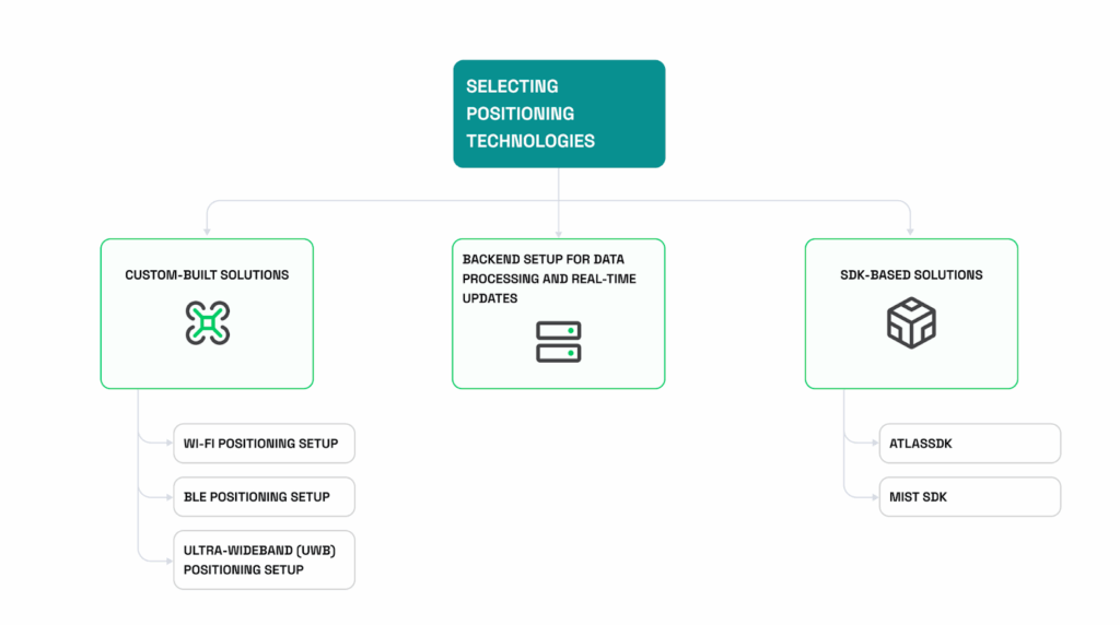
Choosing the right positioning technology is crucial for developing an indoor navigation system, as it affects accuracy, scalability, cost, and user experience. Depending on your project’s specific requirements, you may opt for custom-built solutions or third-party SDKs that provide ready-made positioning capabilities. There are several key technologies used for indoor positioning, each with its own strengths and weaknesses. Here’s a quick comparison:
| Technology | Accuracy | Range | Cost | Setup complexity | When to use |
| Wi-Fi | 5-15 meters | 20-50 meters | Medium | Medium | Wi-Fi is typically used in environments with existing infrastructure. |
| BLE | 1-3 meters | 5-30 meters | Low | Medium | BLE beacons are more accurate and suitable for areas requiring precise positioning. |
| Ultra-Wideband (UWB) | 10 cm – 1 meter | 5-30 meters | High | High | UWB offers the highest accuracy but comes with higher costs and setup complexity. |
When building a custom indoor positioning system, you need to select the right technology, strategically place devices (e.g., Wi-Fi access points or BLE beacons), and potentially develop a backend for data processing and real-time updates. Below are detailed guidelines for setting up each technology.
| Technology | Setup |
| Wi-Fi positioning relies on signal strength measurements (RSSI) from access points. While existing Wi-Fi infrastructure may suffice, additional access points can improve accuracy. | Device setup Devices needed: Standard Wi-Fi access points (APs) that support RSSI measurement. Coverage area: Wi-Fi signals cover a radius of about 20-50 meters indoors, depending on obstacles like walls and furniture. Device placement Corners or hallways: Position APs in corners or along hallways for wide coverage and minimal signal obstruction. Distance between APs: Space access points 15-30 meters apart to allow for overlapping coverage. Height: Place APs at a height of 2-3 meters for optimal signal distribution. Wi-Fi fingerprinting setup Mapping the building: Walk through the building with a device that logs RSSI values at fixed points (e.g., every 3-5 meters). Building the fingerprint map: Store the signal signatures at each location in a database. Real-time positioning: The system compares live RSSI data to the fingerprint map to estimate the user’s position. |
| BLE positioning offers higher accuracy than Wi-Fi, especially when placed strategically in the indoor environment. | Device setup Devices needed: BLE beacons that transmit low-energy Bluetooth signals. Coverage area: BLE covers a smaller radius (5-30 meters), depending on signal strength and obstacles. Device placement Dense areas: Place beacons more densely in high-traffic areas or where precise positioning is needed (e.g., near doorways). Distance between beacons: Space beacons 5-15 meters apart to ensure signal overlap and coverage, especially in complex environments. Height: Position beacons at around 2 meters for optimal signal strength. BLE fingerprinting setup Mapping the building: Walk through the space to record the BLE signal strength at key points. Building the fingerprint database: Create a map of signal signatures for real-time positioning. |
| Ultra-Wideband (UWB) positioning provides very high accuracy (up to 10 cm) by measuring the time of flight of radio signals. | Device setup Devices needed: UWB anchors (fixed devices) and UWB tags (carried by users). Coverage area: Typically 5-30 meters, but more accurate in smaller environments. Device placement Anchor density: Install more anchors in areas requiring high accuracy. Distance between anchors: Space anchors 5-10 meters apart for optimal precision. |
| Backend system is essential for collecting, processing, and updating position data in real time. It performs the following tasks: | Data collection and storage Wi-Fi: APs send RSSI data to the server for triangulation. BLE: Mobile devices collect BLE signal data and transmit it to the backend. UWB: UWB tags communicate with anchors, which send data to the backend. Positioning algorithms Triangulation: Uses signal strength from at least three devices to estimate the user’s location. Fingerprinting: Compares live signal signatures to a pre-recorded fingerprint map. Time-of-Flight (UWB): Measures the time taken for signals to travel between devices. Real-time-updates The system recalculates the position as the user moves, sending updates to the mobile device. API integration Develop APIs to receive signal data, process it using algorithms, and return the estimated location. |
| SDK-based solutions: If custom solutions seem complex, third-party SDKs offer ready-made tools for indoor positioning, combining multiple technologies for robust accuracy. | AtlasSDK Technologies: Wi-Fi, BLE, UWB Features: High-accuracy positioning (up to 10 cm with UWB), multi-sensor support, APIs for integration. Best for: Large-scale projects needing high precision (e.g., hospitals, airports). Mist SDK Technologies: BLE and Wi-Fi Features: Real-time updates, geofencing, cloud management. Best for: Corporate offices, retail environments, and convention centers. |
By carefully selecting and configuring the appropriate positioning technology, you can build a reliable indoor navigation system that meets the accuracy and scalability requirements of your project.
Step 4: Route calculation (choosing pathfinding algorithms and managing vertical transitions in multi-floor buildings)
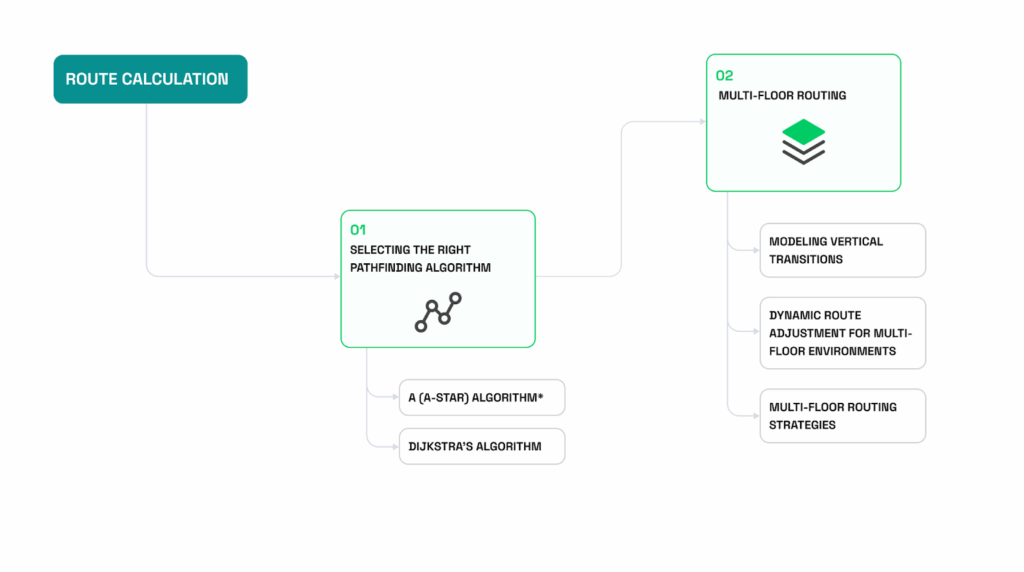
Once the map and positioning system are in place, the next step is to implement a system for calculating optimal routes within the indoor environment. This process involves selecting suitable pathfinding algorithms and managing vertical transitions in multi-floor buildings.
1) Selecting the right pathfinding algorithm
Pathfinding algorithms determine the most efficient routes between locations, taking into account obstacles, distances, and varying travel costs. For indoor navigation, these algorithms need to be fast, accurate, and capable of handling complex environments. The choice of algorithm impacts how efficiently the system calculates routes. Below are details of two popular algorithms used in indoor navigation:
| Algorithm | Ideal use case | Pros | Cons | Speed | Accuracy |
| A (A-star) Algorithm* combines Dijkstra’s algorithm and Best-First Search, using a heuristic to guide the search toward the goal while avoiding unnecessary path exploration. Common heuristics include Euclidean or Manhattan distance. | Ideal for real-time applications where speed is critical, such as guiding users through busy airports. | Fast and efficient for large, complex environments.Works well for real-time navigation due to its heuristic-based search. | Requires a well-designed heuristic for optimal performance. Can be computationally expensive if the heuristic is not accurate. | Fast | High |
| Dijkstra’s Algorithm is known for finding the shortest path in graphs with weighted edges, Dijkstra’s algorithm systematically explores all possible paths. | Suitable for scenarios where accuracy is more important than speed, such as route planning in large buildings with varying travel costs. | Guarantees the shortest path, regardless of graph complexity.Effective for environments where all paths need to be evaluated (e.g., evacuation planning). | Slower than A* for real-time navigation because it does not use a heuristic.Can be inefficient in large environments with many nodes. | Moderate | Very High |
2) Multi-floor routing
Routing in multi-floor buildings requires handling vertical transitions between floors, such as stairs, elevators, or escalators. These transitions must be effectively modeled in the navigation system to calculate accurate routes across different levels.
| Modeling vertical transitions | Sub-graphs for each floor: Treat each floor as a separate sub-graph, connected by “transition nodes” representing vertical connections (stairs, elevators, ramps). Weighted edges for transitions: Assign weights to vertical transitions based on factors like travel time, accessibility, or user preferences (e.g., elevators may be prioritized for users with mobility needs). |
| Dynamic route adjustment for multi-floor environments | Floor detection: Integrate real-time positioning to detect when a user switches floors, and dynamically adjust the route to reflect the new floor. Route recalculation: When a floor change is detected, the system should transition to the corresponding sub-graph and recalculate the optimal route from the new position. Handling obstacles: Update vertical transition nodes in real-time if certain routes become inaccessible (e.g., elevators under maintenance). |
| Multi-floor routing strategies | Direct transitions: For simple cases, directly connect floors using minimal transition nodes. Layered graph approach: Use a layered graph where each floor is a distinct layer, connected by weighted edges representing stairs, elevators, and ramps. This allows for more granular control over vertical movement. Accessibility considerations: Offer options for accessible routes, such as prioritizing ramps or elevators over stairs. |
Step 5: Rendering the route on the map
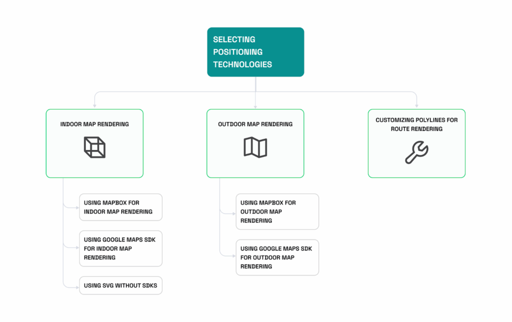
Once the route is calculated, the next step is to display it visually on a map for users to follow. The rendering approach varies depending on whether the environment is indoor (e.g., a building) or outdoor (e.g., campus or streets). Let’s explore methods for rendering routes in both contexts, with or without mapping SDKs, including techniques for using SVG for indoor navigation without relying on third-party platforms.
| Rendering methods | Instructions |
| 1. Indoor map rendering For indoor environments like malls, offices, or airports, rendering involves using custom floor plans (e.g., SVG, GeoJSON, CAD formats) and displaying them as interactive 2D maps. Below are different methods for rendering indoor maps and overlaying the calculated route. | Using Mapbox for indoor map rendering – Upload the floor plan: Convert your floor plan into formats like SVG or GeoJSON and upload it into Mapbox Studio. Customize the appearance by defining layers for different elements, such as rooms, hallways, and points of interest (POIs). – Render the map and route: Display the map in your app and overlay the route using polylines for easy navigation. Polylines connect key points along the calculated path, making the route clear and accessible. Using Google Maps SDK for indoor map rendering – Convert the floor plan into tiles: Use tools like MapTiler to transform the floor plan into a tile format and upload it to a server. – Display the tiles: Render the custom tiles in the app using the Google Maps SDK. – Overlay the route: Draw the route over the map using polylines for smooth navigation. – Using SVG without SDKs If you prefer not to use mapping SDKs, you can render the indoor map directly as an SVG: – Create the floor plan in SVG format: Design the floor plan using vector graphics software and export it as an SVG file. – Render the SVG in your app: Display the SVG in your web or mobile application. – Draw the route with SVG polylines: Add the route using SVG polylines for full customization. This method provides complete control over the map’s appearance without relying on external platforms. |
| 2. Outdoor map rendering For outdoor navigation, such as navigating a campus or city streets, platforms like Mapbox and Google Maps SDK provide robust built-in mapping features. Here’s how to render routes in outdoor environments. | Using Mapbox for outdoor map rendering – Load the pre-built map: Use Mapbox’s API to load an existing outdoor map or customize it to suit your needs. – Draw the route with polylines: Overlay the calculated route using polylines to connect the locations. This makes the route easy to follow. Using Google Maps SDK for outdoor map rendering – Display the built-in map view: Utilize the Google Maps SDK to show streets, public spaces, and other geographical features. – Overlay the route using polylines: Use the Polyline feature to draw the route on the map for clear guidance. |
Polylines are the primary tool for rendering routes, whether within indoor locations or outdoors. Proper customization ensures the route is clear, visible, and easy to follow. Here are some customization tips:
- Color: Choose a distinct color to make the route stand out. For example, use red for indoor routes and blue for outdoor routes.
- Width: Adjust the polyline width for better visibility, especially on mobile devices. Thicker lines may be required for smaller screens.
- Opacity: Fine-tune the opacity to prevent the route from overshadowing other map details. Semi-transparent lines can help maintain map context.
- Dashed or dotted lines: Use dashed or dotted lines to indicate alternative paths, restricted areas, or under-construction routes.
Also, it’s important to consider the specific environment in which the navigation will take place. Different contexts, such as indoor settings, multi-floor buildings, and outdoor areas, require tailored approaches to ensure clarity and usability. Here are some tips for optimizing route rendering in various contexts:
- Indoor space: Use higher-contrast colors and thicker lines to account for complex layouts. Incorporate icons or markers for POIs to enhance navigation.
- Multi-floor buildings: Indicate vertical transitions with specific markers (e.g., stairs, elevators). Use color-coding to differentiate between floors.
- Outdoor environments: Consider using gradient colors along the polyline to indicate changes in elevation or travel speed.
By choosing the right rendering techniques and customizing the route display, you can create an intuitive navigation experience that helps users easily follow the calculated path.
Step 6: Navigation

The final step in providing a seamless user experience is delivering clear, responsive navigation that guides users in real-time to their destination. Robust indoor navigation system requires accurate positioning, intuitive guidance, and the ability to adapt dynamically to changes. Additionally, integrating augmented reality (AR) and accessibility features can greatly enhance the experience, ensuring inclusivity and advanced interaction.
1. Real-time user position tracking
Accurate real-time tracking is crucial for keeping users on the correct path and providing responsive guidance. The system continuously monitors the user’s location and updates navigation instructions accordingly.
- Indoor space: Real-time tracking is achieved using technologies like Wi-Fi, BLE beacons, or UWB, which can accurately locate users within the building’s layout.
- Outdoor environments: GPS-based systems provide continuous tracking in outdoor settings, allowing users to follow streets, pathways, or other routes.
2. Clear navigation instructions
Navigation instructions should be easy to understand and adapt to the environment. The system can deliver directions through visual cues, voice prompts, or text notifications, each of which serves a different purpose.
- Visual guidance: Use arrows, markers, or highlighted paths on the map to give users a clear indication of where to go. Visual cues should update in real-time as the user moves.
- Voice and text prompts: Provide detailed, turn-by-turn instructions such as “Turn right at the next hallway” or “Take the stairs ahead.” Voice guidance is especially useful for users who need to keep their focus on the surroundings without looking at the map.
- Customizing instructions based on context: Adapt the level of detail based on user preferences or environmental factors (e.g., more detailed instructions in complex indoor spaces).
3. Dynamic route adjustment
The indoor navigation system should quickly detect when users deviate from the planned route and offer alternative directions to keep them on track.
- Deviation detection: Use real-time tracking to detect when the user has gone off-route. Trigger automatic recalculation of the path based on the user’s new location.
- Rerouting: After recalculating, provide updated directions to ensure the user can still reach their destination. Offer multiple rerouting options if there are various paths to the destination, allowing users to choose the most suitable one.
4. Multi-floor navigation
Navigating multi-level indoor space adds complexity due to vertical transitions. The system must effectively guide users across floors using stairs, elevators, or escalators.
- Floor transitions: Provide clear instructions for moving between floors, such as “Take the elevator to Floor 3” or “Go up the stairs.” Highlight the nearest vertical transition points on the map.
- Automatic floor detection: Use real-time tracking to detect when the user changes floors. Update the route and navigation instructions to reflect the user’s new position on the correct floor.
- Handling accessibility requirements: If accessibility features are enabled, prioritize routes with elevators or ramps over stairs.
5. Augmented reality (AR) navigation
AR navigation superimposes digital instructions onto the real world through the user’s camera, providing a more interactive and intuitive navigation experience.
- AR visual cues: Display arrows, markers, and directional signs directly on the user’s screen as they view their surroundings through the camera. AR cues can help users follow paths, locate doors, or identify vertical transitions in indoor spaces where visual guidance may be limited.
- Real-world overlays: Enhance navigation by overlaying important information (e.g., exit signs, store names) on real-world objects. This is particularly useful in complex environments like airports, shopping malls, or large corporate buildings where traditional map views may be less effective.
6. Accessibility features for disabled users
Ensuring navigation systems are inclusive requires tailoring features for users with different types of disabilities. Accessibility enhancements include:
- Voice navigation for the visually impaired: Provide detailed voice guidance to help visually impaired users navigate effectively without relying on visual cues. Include descriptions of nearby landmarks or points of interest for more context.
- Haptic feedback: Use phone vibrations to signal turns, important notifications, or changes in direction. This is helpful for users with visual or hearing impairments.
- Accessible routes: Prioritize paths that are accessible for users with mobility impairments, avoiding stairs, narrow hallways, or steep inclines. Include detailed information about ramps, elevators, and other accessible features.
- Customizable preferences: Allow users to set preferences to automatically prioritize accessible routes and adjust navigation instructions based on their needs. Provide options to increase text size, change voice prompt volume, or modify other settings to suit individual requirements.
By incorporating these features, you can deliver a responsive, inclusive, and intuitive navigation experience that meets the diverse needs of users in both indoor and outdoor environments.
How much does it cost to create an indoor navigation app in 2025?
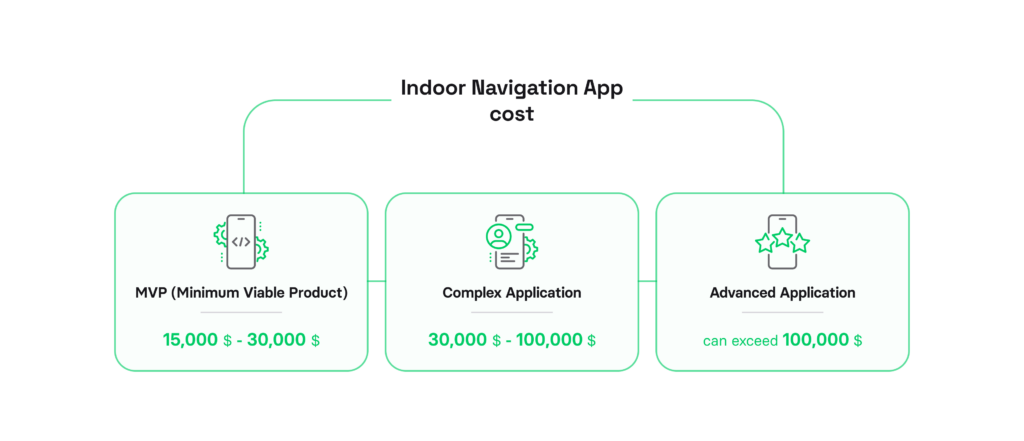
Creating an indoor navigation app can cost from $15,000 to over $100,000. The price can vary based on the features, technology integrations, and overall complexity of the application. Here are some rough estimates based on typical development costs:
1) MVP (Minimum Viable Product)
A basic indoor navigation app with essential functionality—such as simple maps, static POIs, and basic routing—can range from 15,000 USD to 30,000 USD. This version is ideal for testing the app in small venues and gathering initial user feedback.
2) Complex application
For mid-sized venues that require additional features, such as real-time positioning with Wi-Fi or BLE beacons, customizable routing, and enhanced POI details, the development cost can range from 30,000 USD to 100,000 USD. This version caters to venues like hospitals and shopping malls where users need real-time directions and more flexible routing options.
3) Advanced application
A large-scale, feature-rich indoor navigation app—including advanced features such as AR navigation overlays, offline maps, and IoT integration for real-time updates—can exceed 100,000 USD. This version is designed for complex venues like airports and convention centers, providing an interactive and adaptive navigation experience for users.
These are just rough estimates, and actual costs can vary a lot based on the requirements of the business. A good way to manage costs is to start with an MVP so that you can get user feedback and improve the app based on real-world use.
Essential features of indoor navigation apps
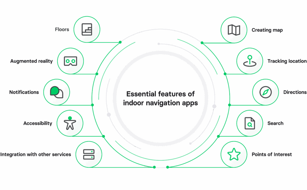
Indoor navigation apps can do a lot, but here are the key features that really count:
| Feature | Description |
| Creating map | Users can create digital maps of indoor spaces or upload existing floor plans. |
| Tracking location | Real-time tracking of where users are inside, using Wi-Fi, Bluetooth, or beacons. |
| Directions | Step-by-step directions to help users get from point A to point B, optimizing for the shortest path. |
| Search | Users can quickly find specific spots or places within the indoor area. |
| Points of Interest | Highlighting important spots like restrooms, elevators, entrances, or specific stores on the map. |
| Floors | Users can choose different floors in multi-level buildings. |
| Augmented reality | Overlaying navigational info on the camera view for a more intuitive experience. |
| Notifications | Sending alerts and notifications for upcoming turns or important information during navigation. |
| Accessibility | Options to assist users with disabilities, including audio instructions and visual cues. |
| Integration with other services | Connecting with transportation or event management apps for added convenience. |
Where can indoor navigation applications be used?

Indoor navigation apps are a solid solution for various spaces. They’re especially useful in retail, transportation, business centers, educational institutions, and medical facilities. Let’s break down how these apps can make life easier in each area:
Retail
Indoor navigation apps in retail make shopping a breeze. Shoppers can whip out their smartphones to navigate big stores and find what they need without hassle. The app offers a digital store map and turn-by-turn navigation, plus it helps plan routes based on your shopping list.
Shopping malls
With so many shops and boutiques, shoppers often feel lost in a mall. Indoor navigation apps help them build routes and quickly find stores, turning a frustrating experience into a fun outing. Instead of wandering around aimlessly, they can get right to what they’re looking for, making them more likely to return.
Train stations and airports
Travelers can struggle to find terminals, ticket counters, and other spots at busy transport hubs. Indoor navigation apps make it easy to plan their journeys. Passengers can quickly locate ticket offices, check-in counters, and cafes, plus get real-time updates on schedules and delays.
Hospitals
Indoor navigation helps patients find doctors’ offices and treatment rooms quickly. The app maps out the shortest paths and accounts for elevators and stairs, which is a game-changer when someone isn’t feeling well.
Universities, colleges, and schools
Indoor navigation simplifies wayfinding in large educational facilities. New students and visitors can easily locate classrooms, cafeterias, and professors’ offices, making campus life less confusing.
Business centers, offices, and property management
No more wandering around looking for the right room. Indoor navigation apps help visitors find their way, cutting down on delays and boosting productivity for everyone.
Hotels & resorts
Indoor navigation apps make exploring large hotels and resorts super easy. Guests can find their rooms, restaurants, and amenities without getting lost. The app helps them discover everything the property has to offer, ensuring they enjoy their stay without any hassle.
Architects & builders
For architects and builders, indoor navigation apps provide a clear view of layouts and designs. They can create detailed maps of new buildings, helping teams navigate during construction or renovation. This makes the planning process smoother and more efficient, reducing confusion on-site.
Stadium & arena management
At stadiums and arenas, indoor navigation apps help fans find their seats, concessions, and restrooms quickly. This means less time wandering and more time enjoying the game or event. Plus, with real-time updates on what’s happening around the venue, fans stay in the loop.
Walking tour guides
Walking tour guides can use indoor navigation apps to create interactive and informative experiences for tourists. The app can guide visitors through historical sites or popular attractions, providing audio or text information at each stop. This makes exploring new places more fun and educational.
National library management
In libraries, indoor navigation apps help patrons locate books, study areas, and resources effortlessly. Users can search for specific titles or subjects and get directions to the right aisle or section, making research and reading more accessible for everyone.
Museums
Indoor navigation apps in museums enhance visitor experiences by guiding them through exhibits. Users can access information about artworks or artifacts as they move through the space, creating a richer, more engaging visit. This helps visitors make the most of their time exploring.
Theme parks
At theme parks, indoor navigation apps ensure visitors can quickly find rides, food, and rest areas. With real-time wait times and directions, families can optimize their day and spend less time waiting in lines. This way, everyone gets to enjoy more attractions and have a blast.
Entertainment venues: Smooth Navigation for Events
Whether it’s a concert, theater show, or festival, users can find their seats and amenities quickly, enhancing their overall experience. This leads to happier guests who are likely to return for more events.
Why build an indoor navigation app?
Let’s check out some solid reasons to consider creating an indoor navigation app for your business::
Space management insights
Your indoor navigation app can hook up with IoT devices to track movement in your building. For example, you can see if folks are always taking the same path or if a specific area is overcrowded. This info helps you manage space better, optimizing how rooms and resources are used. By analyzing where people go, you can tweak less busy areas and move resources to high-traffic spots.
Employee interactions
With the right tech, employees can collaborate more easily. Your app can show real-time availability of meeting spaces and allow instant bookings. This means no more wasting time looking for a place to meet, making teamwork smoother and boosting productivity.
Asset tracking
Indoor maps connected to IoT devices can give you a clear picture of how assets are used. This is especially useful in warehouses or grocery stores. You can plot out the best routes for shipping and packing while keeping tabs on what’s available in your space. With good data management, you can even predict what products are in demand and adjust their locations for easier access.
Energy efficiency
Linking your indoor navigation app to IoT devices lets you gather insights on how the building is used. You can track things like which entrances are popular or how often certain rooms are occupied. Maintenance teams can use this data on their mobile devices for proactive upkeep, which saves money in the long run.
Emergency communication
Your app can be a lifesaver in emergencies. It allows you to send alerts about hazards, escape routes, and safe meeting spots. In case of a fire, for example, it can pinpoint where fire extinguishers are located. Plus, you can analyze how people respond to alerts, improving your emergency plans for the future.
Happy customers
Use the data from your indoor navigation system to gain insights into how people move and what they’re there to do. By providing real-time location info and user-friendly directions, you make navigating your space easy. People are already familiar with GPS apps, so having a similar experience indoors will enhance their visit.
Indoor navigation market size & trends
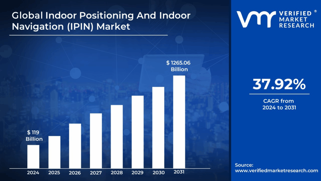
Image source: Verified Market Research
So, let’s talk numbers! The indoor positioning and navigation market is on fire, expected to roll past a whopping $119 billion in revenue by 2024 and shoot up to around $1,265.06 billion by 2031.
Why the hype? Well, more and more folks are using smartphones and smart devices packed with advanced sensors, and that’s driving the demand for killer indoor navigation solutions in places like malls, airports, and hospitals. Plus, businesses are all about enhanced customer experience and operational efficiency. They’re diving into indoor positioning tech to offer personalized services, streamline their operations, and get the lowdown on customer behavior.
These systems are a must-have in big, tricky spaces where GPS signals often go MIA—think retail malls, airports, hospitals, and corporate offices. Companies are using indoor positioning and navigation (IPIN) to amp up the customer experience, smooth out processes, and boost security.
On top of that, the boom in smart buildings and the Internet of Things (IoT) is supercharging the IPIN game. Smart buildings with IPIN can keep tabs on energy use, monitor environmental conditions, and ensure they’re using space wisely. In the industrial world, IPIN helps with asset tracking and staff management, leading to better productivity and safety.
Looking ahead, the future of IPIN is bright, driven by tech advancements and the rising demand for smart infrastructure. Imagine integrating augmented reality (AR) for a next-level navigation experience, or using AI and machine learning to up accuracy and predictive capabilities. With smartphones, wearables, and IoT infrastructure becoming more common, IPIN systems are getting more precise and reliable, which is crucial for smart buildings, healthcare, and industrial settings.
Take hospitals, for example – they’re using IPIN to track medical equipment, monitor patient movement, and optimize resource allocation. In industrial settings, it’s all about asset monitoring, workflow optimization, and keeping safety in check.
Our experience in custom indoor navigation app development
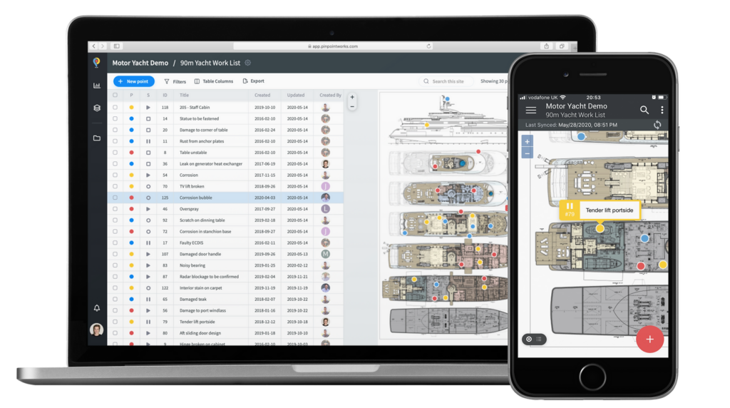
Cruise liner navigation app we built for Pinpoint Works
We invite you to explore our portfolio for a detailed look at the innovative software systems we have developed for our clients.
Our skilled developers leverage the latest technology to create user-friendly interfaces, incorporating features like real-time location tracking, interactive maps, and personalized directions.
With years of experience under our belts, we ensure that your app is not only functional but also visually appealing. And of course, we prioritize on-time delivery, so you can launch your indoor navigation app when you need it.
Let’s bring your indoor navigation app idea to life
Regularly ranked among the Top Custom Software Development Companies on Clutch, Volpis has been leveraging the power of technology to assist business owners in reaching unparalleled milestones. Our team is committed to providing solutions that are tailored to your unique goals.
Whether it’s for a shopping mall, airport, or office building, we tailor the app’s features to fit your requirements. Our process includes designing intuitive user interfaces, integrating real-time data, and ensuring smooth functionality.
We’d love to answer any questions you may have. You can reach out to us via info@volpis.com with any questions or to explore how we can be part of your journey.
Questions & Answers
FAQ
How much does an indoor navigation app cost?
Building an indoor navigation app with essential functionality, such as simple maps, static POIs, and basic routing, can cost from 15,000 USD to 30,000 USD. For mid-sized venues that require additional features, like real-time positioning and enhanced POI details, the development cost can range from 30,000 USD to 100,000 USD. A large-scale, feature-rich indoor navigation app with AR navigation, offline maps, and IoT integration can cost over $100,000. The cost of creating indoor maps also depends on the positioning technology used, as more advanced systems require increased development resources.
How long does it take to build an indoor navigation app?
On average, an MVP (minimum viable product) might take 3-6 months to develop, while a more complex application with advanced features like AR or multi-floor navigation could take 9-12 months or longer. The timeline can vary widely depending on the app’s complexity, the number of features, and the size of the development team. The integration of accurate indoor positioning systems adds to development time but significantly enhances user experience, as it enables precise location tracking even in multi-floor environments.
How frequently should floor plans or navigation data be updated in the app to ensure accuracy?
Updates depend on how frequently changes occur in the building layout. For dynamic environments, like shopping malls with new stores or hospitals with room changes, quarterly updates may be advisable. For more static environments, annual updates may be sufficient. Real-time data updates are ideal for dynamic spaces, such as during temporary events. To maintain high accuracy, creating indoor navigation maps that adapt to layout shifts ensures users have reliable guidance. Indoor mapping solutions can support these updates, especially for complex layouts that require accurate maps. The best indoor mapping solution should also include interactive indoor map features to reflect precise location data changes. Indoor mapping software can streamline the update process, providing building managers with an easy way to create indoor maps that are up-to-date for visitors. It’s recommended to build indoor navigation software that supports automatic data updates, especially for spaces with frequent layout changes.
Are there specific regulations or privacy considerations when using indoor positioning technologies in public spaces?
Yes, there are privacy considerations, especially in the European Union (GDPR) and other regions with strong data privacy laws. It’s important to notify users about data collection practices, obtain consent where necessary, and avoid collecting personally identifiable information unless absolutely required. Working with legal counsel can help ensure compliance with relevant privacy regulations. Indoor positioning technologies collect location data that must be handled with care to protect user privacy. Indoor navigation apps often gather mapping data for interactive maps, but avoiding exact location details of individuals is essential to meet legal requirements. Indoor mapping companies may also recommend using anonymized data to create safer and compliant indoor mapping solutions. In particular, internal sensors and bluetooth beacons can be leveraged for accuracy without compromising privacy by providing general, rather than specific, location details. Businesses that create indoor navigation maps for public use must consider GDPR compliance and ensure no identifiable data is stored or shared.
How can an indoor navigation app be scaled or adapted if the building layout changes significantly over time?
Indoor navigation app can be designed to easily update maps and adjust routes when layouts change. This often involves having a flexible backend that supports uploading new floor plans and re-mapping POIs. Some companies even integrate with a CMS (Content Management System) to simplify map updates, especially useful for large or frequently changing environments. Using mapping tools that allow for the creation of dynamic, scalable indoor navigation maps is key for adapting to frequent layout changes. Mapping providers offer solutions that support automatic updates to digital maps, making it easy to map large buildings with many interactive indoor map features. An accurate map helps ensure visitors receive clear navigation even as changes occur. Indoor navigation technology, coupled with a visual positioning system, enables seamless updates that adapt to new layouts, enhancing user experience. An adaptive indoor navigation system with built-in positioning technology can easily adjust for layout changes, providing seamless transitions and route updates.
What types of testing are needed to ensure the app performs well in various indoor environments?
Testing typically includes functionality testing to ensure routing and navigation are accurate, usability testing to refine the user experience, and environmental testing to assess how physical elements (e.g., walls, Wi-Fi interference) impact app performance. Performance and stress testing can also verify that the app remains responsive under heavy use. Indoor navigation technology testing should verify that indoor location accuracy is maintained despite environmental interference. Testing indoor positioning system components, such as internal sensors and bluetooth beacons, is crucial to ensure location data is consistently precise. Testing should also include scenarios with multiple locations to evaluate how well the app navigates between various indoor spaces. Functional testing for indoor positioning systems ensures that accuracy remains consistent, even in complex environments with multiple floors and numerous POIs. Additionally, usability testing with search functionality can help identify key points and ensure that users can find specific locations quickly.
What data can the app collect, and how can businesses use it for insights (e.g., foot traffic analysis)?
The app can collect anonymized data on user movements, popular POIs, dwell time at locations, peak usage times, and other location details. This data is valuable for analyzing foot traffic patterns, optimizing space usage, and improving services. For example, malls can use these insights to enhance store layouts, while hospitals can improve patient flow. Using an indoor positioning app allows businesses to analyze location data that reveals detailed insights into foot traffic. Interactive indoor navigation maps allow businesses to visually analyze user patterns, helping to improve space layouts based on collected data. Indoor mapping data on user patterns can support improved space management and identify popular routes or congestion points. Interactive indoor maps also provide visual context to help businesses make strategic changes. Accurate maps provide clarity to understand how both the visitors and staff interact with specific locations, allowing for better layout planning.
How can indoor navigation apps improve accessibility beyond basic features like elevators and ramps?
Accessibility features can include voice-guided navigation for visually impaired users, haptic feedback for turn-by-turn instructions, AR for additional context, and optimized routes for wheelchair users. Customizable text sizes, screen contrast options, and dynamic prompts for accessibility-specific routes also contribute to a more inclusive experience. Augmented reality can overlay helpful information on digital maps, making navigation clearer for users with various needs. An indoor navigation map designed for accessibility could include interactive maps that adjust for different disabilities, enhancing user experience. Indoor mapping companies specializing in accessibility features can provide the best indoor mapping solution for diverse environments. Indoor navigation technology should be adaptable to ensure both the visitors and staff can navigate the space comfortably and safely. Implementing an indoor positioning system and indoor navigation maps for accessible routes enhances navigation accuracy and provides smoother experiences for all users.
Can the app function without an Internet connection, and what limitations might there be in offline mode?
Yes, many indoor navigation apps can function offline by storing maps and routes locally on the device. However, features like real-time updates, dynamic rerouting, and cloud-based analytics would be unavailable offline. An offline mode works well for static environments but may need periodic internet access to download updates. Offline indoor mapping software solutions are ideal for environments where connectivity is unreliable, like large, multi-level buildings. However, without the Internet, the indoor positioning system may lack precise updates for dynamic spaces. Google indoor maps and other similar digital maps often require online connectivity for the latest data, limiting interactive features when offline. Indoor positioning app functionality can still guide users but may lack the ability to identify key points with the same accuracy.
What maintenance or ongoing costs should be expected after the app’s initial launch?
Maintenance costs generally include regular updates, bug fixes, feature enhancements, and data hosting. These costs are typically 15-20% of the app’s initial development cost annually. Additional costs may arise if there are significant changes to building layouts or if new features are added based on user feedback. Regular maintenance for indoor mapping software ensures that indoor navigation maps remain accurate and responsive to user needs. Indoor mapping solutions may require updates to the mapping data to support interactive features and real-time navigation. Choosing an indoor mapping solution with integrated CMS tools can help streamline these updates and control costs.
