Airports have innovated almost everything — self-check-in, biometric boarding, mobile tickets. But when it comes to helping people move through a terminal, most are still stuck in 2005.
Static signage. Vague map kiosks. Overloaded mobile apps.
For travelers, that means missed gates, confusion, stress. For airports, it means congestion, lost retail revenue, and poor passenger satisfaction scores.
The fix isn’t more maps, it’s smarter guidance.
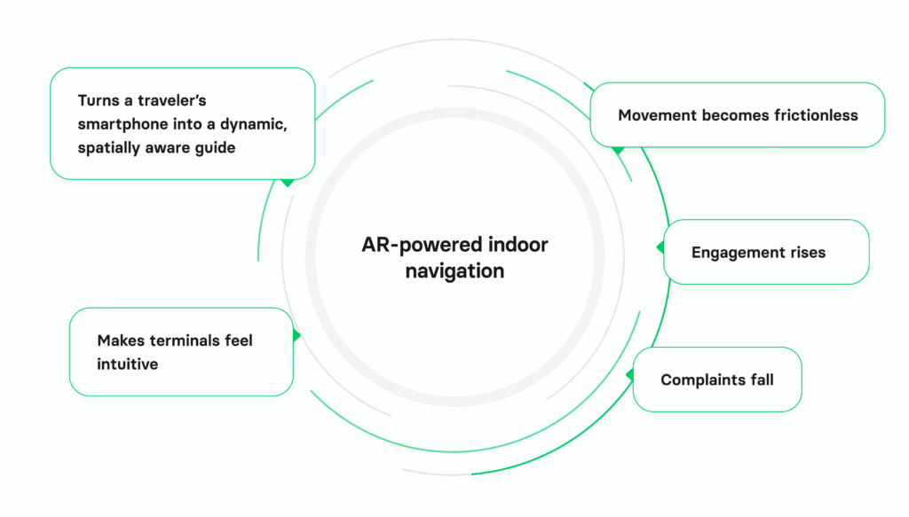
AR-powered indoor navigation turns a traveler’s smartphone into a dynamic, spatially aware guide. Done right, it makes terminals feel intuitive. Movement becomes frictionless. Engagement rises. Complaints fall.
At Volpis, we’ve helped build real-time navigation systems in environments just as complex as airports — large warehouses, logistics hubs, and multi-level facilities. In this article, we’ll break down what makes augmented reality navigation a game-changer for aviation, where it delivers the most impact, and what’s needed to build it properly.
If you have any concerns about implementing AR indoor navigation in the airport, we would be happy to answer all your questions and give honest advice. You can always reach out to our team via info@volpis.com
What AR indoor navigation actually does
AR-powered indoor navigation replaces static maps with real-time, spatially anchored visual guidance. Instead of reading signs or deciphering floor plans, travelers simply hold up their phone and follow intuitive on-screen directions overlaid on the real world.
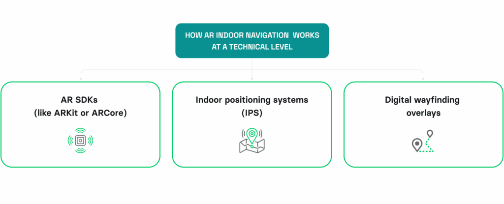
Here’s how it works at a technical level:
- AR SDKs (like ARKit or ARCore) use the phone’s camera and motion sensors to understand the user’s position and orientation in 3D space.
- Indoor positioning systems (IPS) — including Bluetooth beacons, Wi-Fi RTT, or visual SLAM — provide accurate location tracking without relying on GPS.
Digital wayfinding overlays — arrows, paths, prompts — are anchored to real-world points and update dynamically as the user moves.
The result is a guided, personalized experience that adapts to layout changes, gate shifts, and traveler needs, without requiring them to interpret abstract maps.
Unlike conventional apps, AR doesn’t just tell users where to go — it shows them, with contextual accuracy.
This opens the door to much more than wayfinding: personalized notifications, multilingual support, real-time rerouting, and even smart commercial engagement — all layered on top of the real environment.
Why airports are a perfect fit for augmented reality navigation
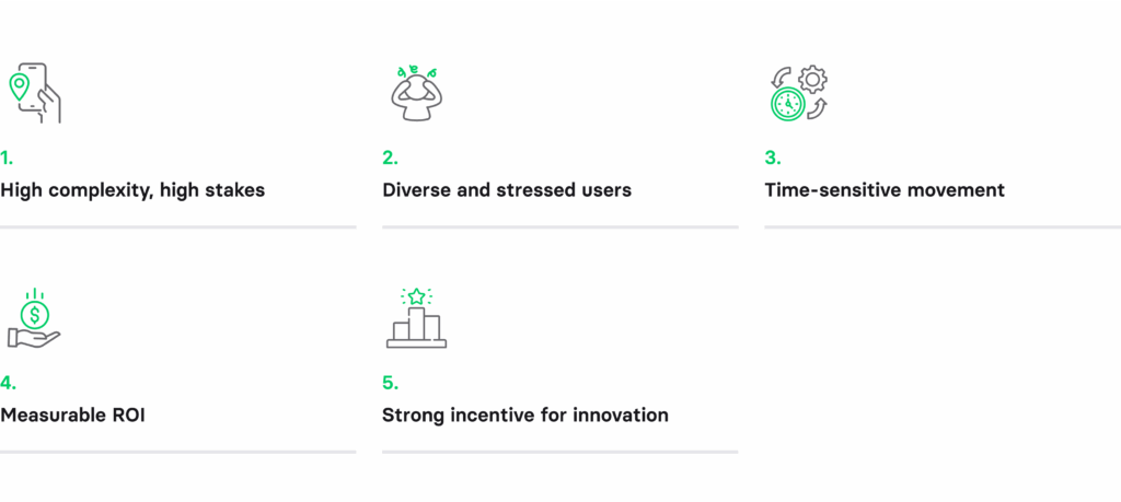
Few environments are as dynamic, high-stakes, and spatially complex as airports. That’s exactly what makes them ideal for AR-powered indoor navigation.
1) High complexity, high stakes
Airports are multi-terminal, multi-level environments that change constantly — temporary gate moves, rerouted traffic, and construction zones are the norm. Traditional signage can’t keep up. Augmented reality solves this by adapting the experience in real-time, guiding travelers based on live layouts and operational data.
2) Diverse and stressed users
Passengers include tourists, frequent flyers, families, elderly travelers, and people with limited mobility, often navigating under pressure. AR lowers the cognitive load by eliminating the need to interpret maps or signage. Instead, users follow clear, visual prompts in their native language or accessibility mode.
3) Time-sensitive movement
A delayed boarding call. A 30-minute layover. A changed gate. Every minute counts. AR ensures passengers don’t waste time figuring out how to get from A to B — they just follow the path.
4) Measurable ROI
Every frustrated traveler is a missed opportunity — in duty-free, lounges, food courts. By reducing confusion and increasing dwell time in commercial zones, AR wayfinding can directly boost non-aero revenue.
5) Strong incentive for innovation
Airports compete globally for efficiency, experience, and traveler loyalty. AR navigation is a visible, high-impact way to show leadership, especially when integrated into broader digital transformation initiatives.
Real-world use cases of AR indoor navigation in the airport environment

AR indoor navigation is more than a flashy demo — it solves real, operational problems in airports. Here’s where it delivers meaningful value:
Seamless gate-to-gate navigation
Travelers land in one terminal and need to catch a connection across the airport. AR shows them exactly where to go — floor by floor, hallway by hallway — with turn-by-turn overlays. No guesswork, no delays.
Real-time rerouting during disruptions
When a gate changes last-minute, most passengers miss the update or scramble to read a map. With AR, the route auto-adjusts. The path literally shifts in front of them.
Accessibility & multilingual UX
AR enables inclusive navigation. Visual overlays can be paired with voice prompts, larger icons, and alternative routes for wheelchair access. Multilingual labels improve clarity for international travelers.
Smart commercial engagement
Heading to Gate 25? If you have 30 minutes, AR can prompt you to detour to a nearby lounge, coffee shop, or duty-free deal, with directions tied to your current location and time buffer.
Operational efficiency for staff
It’s not just for passengers. AR can guide airport staff to equipment, maintenance locations, or restricted zones, reducing training overhead and improving response times.
Real-world examples of how AR indoor navigation can help optimize operations in airports
Let’s take a look at a few examples:
Incheon International Airport (South Korea)
It uses AR in its mobile app Incheon Airport +, to provide directional arrows overlaid on camera view. Travelers navigate terminals intuitively, with smoother flows and reduced stress.
Gatwick Airport (UK)
One of the early adopters, Gatwick Airport, combined Bluetooth beacons with AR overlays to help passengers to find their way.
Changi Airport (Singapore)
Trialed AR features as part of its smart airport initiative — enabling camera-based routing to gates, shopping, and services with multilingual AR cues.
Leading airports are already implementing AR navigation to future-proof the passenger journey. The opportunity isn’t theoretical anymore. It’s competitive.
Strategic benefits of AR indoor navigation for airports

AR indoor navigation isn’t just a better UX — it’s a business tool with tangible returns across passenger experience, operations, and revenue.
1) Improved passenger experience
Lost, late, and frustrated passengers are the norm in large airports. AR reduces stress, speeds up movement, and gives travelers confidence, especially in high-pressure situations like tight connections or unfamiliar terminals.
Outcome: Higher CSAT scores, stronger NPS, better airline and brand perception.
2) Increased non-aero revenue
When travelers feel lost, they focus only on getting to the gate. With AR guidance and time-aware prompts, airports can surface high-margin services — lounges, retail, F&B — exactly when and where passengers are most likely to act.
Outcome: More conversions, more dwell time in profitable zones.
3) Operational efficiency
AR isn’t just for passengers. Maintenance teams, airline staff, and new hires can navigate restricted or complex areas without asking for directions or relying on paper maps.
Outcome: Faster orientation, fewer support calls, more responsive ops.
4) Crowd Flow Optimization
In peak hours, even small delays or confusion can cause ripple effects. AR navigation allows airports to influence passenger flow in real-time, distributing movement across terminals and easing congestion.
Outcome: Fewer bottlenecks, smoother boarding, reduced security wait times.
5) Innovation as Differentiator
Modern travelers notice when airports feel behind. AR is a visible, user-facing innovation that shows passengers and partner airlines that the airport is investing in smarter, more seamless infrastructure.
Outcome: Competitive edge in a global travel ecosystem.
Key tech stack components
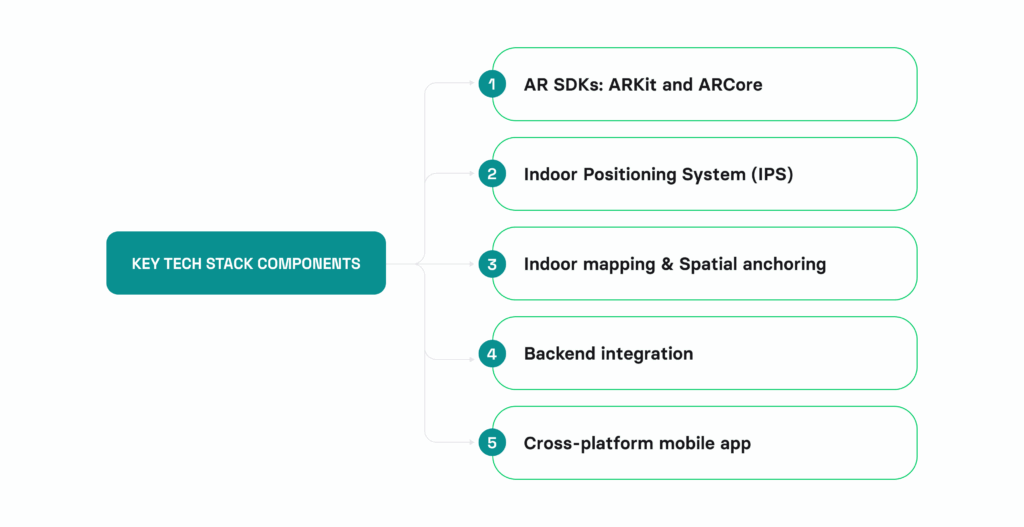
Delivering AR-powered indoor navigation in an airport isn’t about prototyping a camera overlay — it’s about stitching together real-time systems, spatial data, and resilient mobile infrastructure. Here’s what it takes:
1) AR SDKs: ARKit and ARCore
- Core tools for anchoring digital elements to real-world spaces.
- Support features like surface detection, motion tracking, and scene understanding.
- Critical for rendering visual navigation that adapts to user movement.
2) Indoor Positioning System (IPS)
- GPS doesn’t work indoors. IPS replaces it using Bluetooth beacons, Wi-Fi RTT, Visual SLAM (Simultaneous Localization and Mapping), or hybrid models combining multiple signals.
- Ensures high-accuracy positioning even in dense, multi-level terminals.
3) Indoor mapping & spatial anchoring
- Accurate, up-to-date 2D and 3D floor plans are foundational.
- Points of interest (gates, shops, elevators) must be mapped precisely to enable meaningful navigation.
- Real-time changes (gate updates, closed areas) need to sync with the app backend.
4) Backend integration
- AR navigation must connect with airport systems: flight schedules, gate assignments, retail APIs and accessibility routing logic.
- This ensures the app responds in real time, not just hardcoded paths.
5. Cross-platform mobile app
- Performance matters. You need native apps that run smoothly across modern iOS and Android devices, with fallback modes for older hardware.
- Multilingual UX, accessibility settings, and low-light adaptation must be part of the build, not afterthoughts.
At Volpis, we build these layers into one unified system, ensuring the AR experience is more than just technically functional. It’s reliable, intuitive, and enterprise-ready.
How to implement AR indoor navigation at airports: step-by-step process
Airports are complex spaces with multiple floors, security zones, and fast-changing schedules, so creating a reliable AR navigation system requires careful planning and integration of several technologies. Here’s how to approach it.
Step 1: Define core goals
Start by identifying the main pain points for travelers that your AR system will solve. Airports have diverse user groups — from first-time tourists to frequent flyers — all needing to find gates, restrooms, baggage claims, lounges, or restaurants under time pressure. Focus on solving specific navigation problems such as locating check-in counters, moving from security to gates, or guiding passengers to connecting flights. This step sets the foundation for the entire design and technology stack.
Step 2: Acquire or create indoor maps
You’ll need highly accurate, up-to-date digital maps of the airport’s interior. This includes terminal layouts, gate numbers, amenities, floors, and even staircases and elevators. Many airports already have CAD files or BIM (Building Information Models), but if those are unavailable or outdated, you may need to use 3D scanning tools like LIDAR or photogrammetry to create your own. These maps will serve as the digital canvas where your AR navigation paths will be overlaid.
Step 3: Choose an AR development platform
Select the right AR platform based on the devices you plan to support. For iOS, ARKit development is the native approach; for Android, ARCore development is the standard choice. If you want a cross-platform solution, Unity with AR Foundation is ideal, especially for handling large environments like terminals. Your platform should support plane detection, motion tracking, and the ability to anchor AR content accurately in a 3D space. Choosing the right SDK early on ensures scalability and smoother development down the line.
Step 4: Set up indoor positioning infrastructure
Since GPS is unreliable indoors, you’ll need to implement an alternative indoor positioning system to determine the user’s location. In airports, a common solution is to use Bluetooth beacons placed at strategic points throughout the terminal. These allow triangulation of a user’s position. You can also combine this with Wi-Fi RTT for improved accuracy or use visual positioning systems that rely on the phone’s camera to recognize the environment. The more accurate your positioning system, the more reliable your AR navigation experience will be.
Step 5: Build the AR navigation experience
With mapping and positioning in place, start designing the AR interface. The goal is to guide users from their current location to their destination using digital overlays like arrows, paths, and floating signs. These elements appear in the camera view and update as the user walks. The design must be intuitive, unobtrusive, and quick to interpret — especially since travelers are often stressed or in a rush. Consider adding audio guidance, distance counters, or notifications when the user is approaching a checkpoint like a security gate or boarding area.
Step 6: Integrate real-time airport data
To make the navigation system responsive and context-aware, integrate it with live airport data systems. This includes flight schedules, gate assignments, security wait times, and baggage carousel locations. If a gate changes, the app should automatically reroute the passenger using AR. Similarly, it can highlight shorter security lines or notify travelers if there are delays. Real-time data is critical for making AR navigation practical and dependable in a fast-paced airport environment.
Step 7: Test in real conditions
Before going live, test the system in the real airport environment under different scenarios. Evaluate how the AR elements behave with variable lighting, crowds, and walking speeds. Check if the positioning system remains accurate across all terminals and levels. It’s also important to test for edge cases like broken beacons or temporary closures. Gather feedback from real users — including passengers, airport staff, and people with disabilities — to identify friction points and usability issues. This testing phase ensures reliability and helps build trust in the system.
Step 8: Launch, monitor, and maintain
Once validated, launch the AR navigation feature as part of the airport’s main app or as a standalone tool. Inform travelers through signage, QR codes, or airport staff. After deployment, monitor system performance, update maps when layouts change, and replace batteries in beacons as needed. Regular maintenance is essential to keep the AR experience accurate and helpful over time. Consider collecting anonymized usage data to improve future versions and uncover trends, such as the most frequently used paths or areas where users get lost.
How Volpis can help you build AR-powered indoor navigation for your airport
Most AR navigation projects fail in execution, not ambition. The visuals might work in a demo, but without robust mapping, real-time integration, and mobile engineering experience, the product stalls at prototype.
That’s where Volpis comes in.
Consistently recognized as one of the Top Custom Software Development Companies on Clutch, Volpis harnesses the power of augmented reality technology to build apps with integrated indoor maps.
We create production-ready AR navigation systems for environments where precision, scalability, and UX matter — from warehouses to logistics hubs to multi-level commercial spaces. Airports are a natural fit. We invite you to explore our portfolio for a detailed look at the innovative software systems we have developed for our clients.
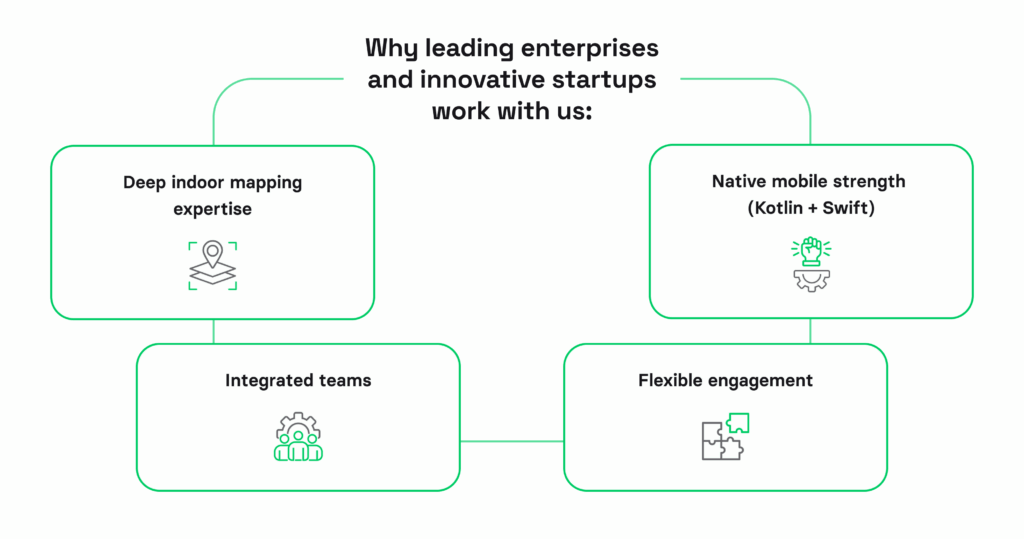
Why exactly leading enterprises and innovative startups around the globe choose to work with us:
- Deep indoor mapping expertise: We know how to turn architectural plans into dynamic navigation layers — and keep them accurate as layouts evolve.
- Native mobile strength (Kotlin + Swift): We build high-performance AR apps optimized for battery life, UX, and offline fallback.
- Integrated teams: Our design and dev teams work as one, meaning faster execution, cleaner UX, and fewer handoff issues.
- Flexible engagement: Whether you need a fast MVP, a pilot rollout, or full-scale development, we adapt to your internal capabilities.
Our commitment to excellence is reflected in the glowing reviews from our customers, who consistently praise our dedication to delivering exceptional results.
If you’re evaluating AR navigation, don’t start with the SDK. Start with the strategy. We’ll help you scope the right architecture, identify constraints, and build a solution that moves people, not just pixels.We’d love to answer any questions you may have about AR-powered indoor navigation at airports. You can always reach out to us via info@volpis.com with any concerns or to explore how we can be part of your journey.
FAQ
How long does it take to launch an MVP for AR indoor navigation in an airport?
A focused MVP can be developed in 3–4 months, assuming floor plans, anchor zones, and basic route logic are available. Enterprise-ready versions take longer due to security, system integrations (e.g., flight data, gate management), and stakeholder validation. Volpis typically phases delivery — starting small, then scaling.
What’s the typical cost to develop AR navigation for an airport?
It depends on the scope. A pilot for one terminal might start at $60K–$150K, including mapping, mobile app, and basic routing. Full-scale deployments with cross-terminal logic, backend integration, and multilingual UX can range from $150K–$300K+. Cost is highly sensitive to how dynamic your layout is and how much of the infrastructure already exists. Pricing also depends on the use of various technologies like Bluetooth beacons, geolocation systems, and Visual SLAM for precise indoor tracking. Custom integrations with retail outlets and luxury brands to guide users to shops or promotions can increase complexity and cost. Designing for high passenger flow areas with rapid movement — like security checkpoints — requires more resilient tech. Airports investing in advanced digital information features, such as flight delay notifications and path rerouting, will need additional backend development. Planning for long-term scalability means budgeting for updates as future trends in indoor tech evolve. Ultimately, the cost reflects the depth of integration across routes, facilities, and commercial layers.
How do we keep the system accurate with ongoing construction and layout changes?
Volpis builds with dynamic spatial mapping and modular anchors. Instead of hardcoding routes, we connect them to a backend CMS. When a corridor is closed or a gate changes, the update is pushed server-side — no app redeploy needed. This avoids stale directions and reduces maintenance overhead. To support ever-changing airport operations, our systems use a real-time syncing mechanism that pulls layout data and syncs routes instantly. These updates can redirect travelers around construction or newly added retail stores without any friction. Using indoor location tech, the system recalibrates dynamically based on user movement. Interactive maps reflect updated floorplans across all facilities, ensuring no confusion even when temporary detours exist. Because passenger habits adapt quickly, accurate routing must reflect shifting passenger flow and foot traffic patterns. This dynamic response not only enhances the visitor experience but also maintains operational continuity across boarding gates, escalators, and checkpoints.
What’s the real ROI for airports beyond better UX?
Airports using AR navigation see increased non-aero revenue through better commercial engagement (duty-free, F&B), fewer missed flights, reduced signage reliance, and smoother crowd flow. For large hubs, even a 2–3% uptick in lounge or retail conversion makes the investment ROI-positive.
What devices are supported, and will travelers need to install anything?
Most modern smartphones (iPhone 11+, mid- to high-end Androids from 2020+) support AR navigation via ARKit/ARCore. Users typically access the AR experience through the airport’s mobile app, though lightweight WebAR versions are possible for simpler use cases.
Can AR navigation work offline or in low-connectivity zones?
Yes — we design for partial or full offline support. Core route logic and spatial anchors can be cached on-device. Real-time updates (like gate changes) require connectivity, but fallback paths and static navigation still function even in dead zones like basements or tunnels. Offline support is essential in large terminals where passenger flow extends across areas with weak signals. The system uses cached routes to help travelers locate boarding gates, restrooms, and facilities even when Wi-Fi drops. This ensures accessibility across all concourses — from lounges to distant retail stores. Travelers can still view interactive maps and location-based prompts without delay, reducing anxiety during transit. Offline AR helps ensure consistent airport operations, even in emergency scenarios when digital infrastructure is strained. This resilience improves both safety and trust in the system’s reliability.
How secure is this from a data privacy standpoint?
We build with privacy by design. Location data is processed on-device, and no user-facing session data needs to be stored unless analytics or personalization are explicitly required. All integrations with airport systems follow enterprise-grade security protocols.