
If you plan to develop an application that requires geolocation services, you probably already noticed that there are several APIs available. The most popular ones are Google Maps APIs and TomTom Maps APIs.
Google developed a robust API platform that offers many different types of solutions. And TomTom is a direct competitor to Google Maps Platform.
But what is better for geolocation app development: TomTom Maps APIs vs Google Maps APIs? Both offer powerful mapping and navigation capabilities, but they have some key differences.
Let’s compare TomTom Maps APIs vs Google Maps APIs, so you could make the best decision for your business. They both are valuable tools our developers use when building applications for our clients, including Fleetsu and Road Hunter.
TomTom Maps API vs Google Maps API: a detailed comparison
Are you trying to make a choice between TomTom Maps APIs and Google Maps APIs for your app? In addition to providing navigational help and helping users find routes, both TomTom Maps APIs and Google Maps APIs offer real-time data to ensure accurate and up-to-date information for optimal navigation.
While they both offer great services, there are some key differences between the two. Which of the two should you opt for?
| TomTom Maps APIs | Google Maps APIs | |
|---|---|---|
| Cost | TomTom provides 2,500 data requests for free each day, after which developers can pay $0.50 for each subsequent 1,000. | You’re allowed up to 28,000 free map displays per month, with the charge for every subsequent 1,000 amounting to $7.00. |
| Routing | TomTom GO collects data from over 400 million cars and updates the information every two minutes. | Google Maps APIs collect data from various sources, including Android Phones, satellite imagery, geological surveys, etc. |
| Offline navigation | When you first open the TomTom GO app, you’ll need to download the entire country’s map. | Google Maps APIs allow users to download a portion of the map for offline use, and users can download multiple areas at once. |
| Transport modes | Car, bicycle, walk | Car, bicycle, public transportation, taxi/ride-share, walk |
| Road closures | A vailable | Google Maps APIs do not display road closures. |
| Contributions | Not available. | Users can contribute by reviewing and rating places, uploading photos, and answering questions. |
| 3D and 2D | TomTom has the feature of displaying everything in 3D figures. | Google Maps APIs display everything in 2D figures. |
| What companies use |
|
|
| Receiving information | Tomtom downloads the entire map to your phone. | Google Maps APIs stream data to your phone. |
| Voice navigation | TomTom GO offers over 100 voice options in many languages. | Google Maps APIs have 59 voice options. |
Also, TomTom Maps API’s and Google Maps API’s compatibility with Android Auto allows users to have an enhanced, hands-free navigation experience directly from their car’s dashboard.
Both Google Maps APIs and TomTom Maps APIs are considered to be two of the best options out there. If you’re looking for reliable APIs. TomTom Maps API integration offers numerous advantages, however, Google Maps APIs have some unique features that might make it a better fit in some situations.
Google Maps APIs: top features and benefits for your business
Source: How to Use the Google Maps API: Introduction
Google Maps APIs dominate in the arena of navigation apps. Among its many functionalities, Google Maps displays a diverse range of data including traffic conditions, public transit routes, businesses, and landmarks, offering a comprehensive view of the surrounding area.
Google Maps APIs features
Below are some key new features that the excellent Google Maps came up with to integrate into the mobile app for business.
The Geocoding API
Geocoding API provides a direct way to convert an address into latitude and longitude coordinate values. Reverse geocoding, which converts coordinates into human-readable addresses, is also possible with the Google Maps Geocoding API. This feature is part of the baseline functionality of the Google Maps API and is used extensively in location-based applications.
The Directions API
The Google Maps Directions API service calculates driving distances between two points and renders both text and an interactive map of turn-by-turn directions. Furthermore, Google Maps Navigation offers turn-by-turn directions, which is a crucial feature for apps requiring precise and user-friendly navigation. Locations can be specified by the user or a geolocation service that returns the user’s location as latitude and longitude coordinate values.
Street view panorama
This service allows users to experience a real-world view of a specific address. Google Street View provides panoramic views of roads throughout its coverage area.
Heat maps
Heat maps are representations of geospatial data on a map that use different colors to show areas with different groupings. They show overall shapes and group trends. Heat maps are also known as “intensity maps”.
Style maps
You can enhance your app by incorporating style maps. They let you customize the look of Google map styles, changing the visual display of features like roads, parks, etc.
Ground overlay
Ground Overlays are high-resolution images that are attached to latitude/longitude coordinates and run as you drag or zoom the map.
Indoor maps
Indoor maps allow users to get directions and find points of interest inside a venue. This feature can be integrated into existing applications for mobile and desktop, or as a standalone service.
Marker clustering
When there is a lot of data to display, it is easy for your information to become cluttered and disorganized. One way to solve this problem is to create clusters of similar markers. When you zoom out, you can see an overview of your data, and when you zoom in, the clusters separate so that you do not lose any detail.
Map layers
Layering can be applied to maps to enhance their functionality. It can identify regions, service areas, or other areas of interest for the business.
Circles
Circles represent the area around us. The radius is approximately 20 to 30 kilometers from our location. The design can be dotted, plain, or dashed.
Auto latitude and longitude
Auto latitude and longitude are used to help track the person’s exact location. This feature automatically takes the latitude and longitude values of the area where the person is located.
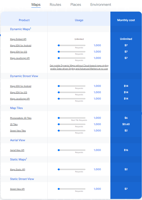
Google Maps APIs pricing in 2025
Google Maps Platform offers flexible pricing, daily quotas, and 28,500 maploads per month for no charge. Here is Google Maps APIs pricing structure breakdown:
TomTom Maps APIs: top features and benefits for your business
Source: Intro to TomTom Maps APIs: Maps; Traffic; Search; Routing; Geofencing
TomTom Maps APIs integration into a mobile app offers numerous benefits. These location technologies enable you to create a range of products, including mobile and web apps, in-dash navigation systems, and fully autonomous driving solutions.
TomTom Maps APIs features
TomTom Maps APIs permit you to easily build applications that need to be location-aware. It offers different cross-platform REST APIs and SDKs to enable you to create applications with mapping, routing, search, navigation, and traffic features. Let’s take a closer look at TomTom Maps APIs.
Map Display API
The Map Display API helps developers to create web and mobile applications around mapping. Examples of common use cases include displaying a map of the whole world with zooming and panning, displaying a map of a specific country, and showing a map centered on a given location with detailed surroundings.
TomTom Traffic API
The Traffic API is used to create applications around real-time traffic. You can use real-time traffic products or historical traffic analytics. The offering is split into Traffic Incidents, which provides an accurate view of traffic jams and incidents, and Traffic Flow, which provides real-time observed speeds and travel times for all key roads in a network.
Routing API
Routing helps to calculate departure times by planning routes using desired arrival times, the travel time of pre-existing routes, a batch of up to 700 routing requests in parallel, and routing costs for each origin-to-destination combination.
Search API
Search allows single-line fuzzy search for addresses and POIs. It assigns latitude/longitude coordinates to a specific address, geographic feature, or point of interest. You can search for an address, Points Of Interest, or a combination of both.
TomTom Maps APIs pricing in 2025
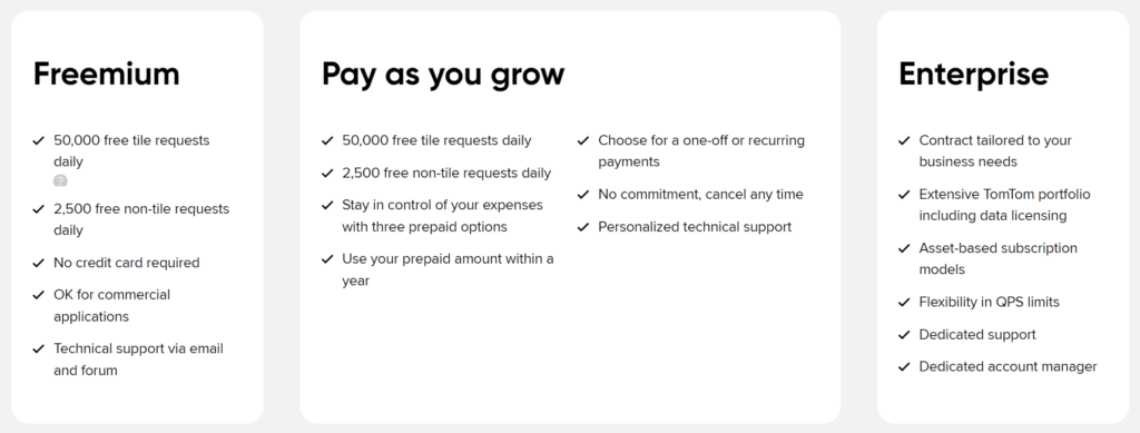
You can use free API requests every day. As your business grows, you can use the Pay As You Grow plan. Here is TomTom Maps APIs pricing structure breakdown:
1) Freemium
- 50,000 free tile requests daily
- 2,500 free non-tile requests daily
- No credit card required
- OK for commercial applications
- Technical support via email and forum
2) Pay as you grow
- 50,000 free tile requests daily
- 2,500 free non-tile requests daily
- Stay in control of your expenses with three prepaid options
- Use your prepaid amount within a year
3) Enterprise
- Contract tailored to your business needs
- Extensive TomTom portfolio including data licensing
- Asset-based subscription models
- Flexibility in QPS limits
- Dedicated support
- Dedicated account manager
TomTom Maps API vs Google Maps API: what maps API is best for your app?
Google Maps APIs and TomTom Maps APIs are both excellent options for map APIs. But there are some areas where they outperform one another.
Map updates
One of the crucial aspects of a successful navigation app is the frequency and accuracy of map updates. Google Maps API, with its extensive data sources, often provides more relevant traffic information, which can be crucial for applications focused on real-time navigation and logistics.
Traffic data
TomTom Maps APIs and Google Maps APIs both provide valuable traffic data, aiding in real-time navigation. The big difference lies in distribution. Google streams its map data, so it can have maps that are always up-to-date. Given its infrastructure, Google Maps APIs stream data in real-time, ensuring the most current and accurate information is always available to the user.
Google Maps APIs are renowned for provision of accurate data worldwide, making it a reliable choice for global navigation needs. If your app requires the most up-to-date global data and highly accurate location information, then Google Maps would be the preferred choice.
Additional features
Another key difference is that Google Maps APIs offer additional features, such as the ability for users to upload photos, which enhances the overall experience while providing valuable information for other users. But if you are looking specifically for a driving navigation app, TomTom Maps API is your best choice. There’s less clutter on the screen and the simplistic design allows drivers to focus on the road.
Another feature that app developers might consider important is the ability to display speed camera locations, which both Google Maps APIs and TomTom Maps APIs offer.
Battery life
TomTom Maps APIs allows you to reduce bandwidth consumption and increase performance stability. It can work without an internet signal and potentially saves users battery life as there is no need to continuously sync with a server.
TomTom’s ability to download the entire map to your phone is an excellent feature for offline maps usage, allowing navigation without a constant internet connection.
Integration
Google Maps APIs and TomTom APIs allow for seamless integration with Android phone and IOS devices, providing a user-friendly interface and smooth performance. It’s worth noting that they also provide Apple CarPlay support, allowing seamless integration of their mapping and navigation features into compatible vehicles.
If you opt for TomTom Maps APIs for your app, you’ll benefit from a user-friendly interface with less clutter on the screen, allowing drivers to focus on the road.
If you want to integrate Google Maps APIs into your app, keep in mind that it is superior in terms of accuracy, availability, and depth of its map data for many locations. They are more up-to-date and potentially have more relevant traffic information.
Top use cases of TomTom Maps API and Google Maps API
From searching for directions on Google Maps APIs to hailing a taxi via Uber, geolocation apps have become an essential part of our everyday lives. The number of use cases is proliferating. Developers invent innovative new ways of leveraging these tools, including
Ride-hailing and ride-sharing
Local initiatives, startups, and big companies use real-time data on traffic conditions, road conditions, weather, and more to grow their businesses.
Electric cars
As more people purchase electric vehicles, developers are paying attention to their needs and trip-planning strategies.
Financial services
Location data can be used to predict housing prices, using APIs that provide information about schools, tourist attractions, public transit stops, or the most congested areas of a city.
Fleet and logistics
Companies can track their vehicles, plan the fastest routes to deliver a truck full of packages, receive real-time alerts about speed traps, and find the most efficient ways to avoid traffic jams so they can ensure deliveries are made on time.
Connected cars
As the number of connected cars has grown, so have demands for in-car navigation and third-party applications; this is especially important for leasing and rental services as well as for insurance companies.
Analytics and big data
Location services provide data scientists with valuable information, allowing them to improve their data models and visualize their analyses.
To put all this together, a diverse set of Map APIs is required. In terms of geolocation and mapping technology, both Google Maps APIs and TomTom Maps APIs have established themselves as leading solutions, each with its unique strengths and capabilities.
Our experience with navigation app development and integration of mapping APIs
Volpis is a software development company that specializes in custom navigation app development.
Over the years, our team at Volpis has successfully produced mobile apps integrating both Google Maps APIs and TomTom APIs for various businesses. We have worked with many successful brands, including Fleetsu, Road Hunter, and FlowMSP.
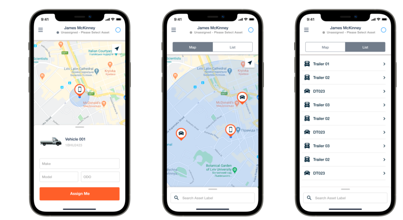
Fleetsu app we built
We can help your business succeed through the development of robust, creative map applications. Our experts are specialized in developing navigation apps for both Android and iOS platforms.
At Volpis, we’ve been doing it for years, and we can apply this experience to meet your business needs.
Do you need to integrate TomTom Maps API or Google Maps API into your app?
Google Maps APIs and TomTom Maps APIs both offer a wide range of mapping APIs to suit the needs of different applications. When it comes to choosing between these two giants in the mapping industry, it’s essential to consider your specific business needs.
Our experienced developers are ready to help you integrate these APIs into the mobile apps with the latest features, help you build your MVP, and scale to the next level.
Consistently recognized as one of the Top Custom Software Development Companies on Clutch.co, Volpis harnesses the power of augmented reality technology to help business owners achieve remarkable milestones. We have successfully developed more than 100 web and mobile applications for our valuable customers.
If you have any questions about Google Maps APIs and TomTom APIs, you can reach out to us via info@volpis.com, we would be happy to help you.
Questions & Answers
FAQ
What are TomTom Maps APIs and Google Maps APIs?
TomTom and Google Maps APIs are a way to integrate mapping and navigation features into applications. These APIs provide real-time traffic updates, crucial for efficient route planning in your application. Moreover, these APIs deliver accurate data worldwide, ensuring consistent and reliable geolocation services across different global regions.
Is Google Maps better than TomTom Maps APIs for app development?
It depends on what you’re looking for. TomTom Maps APIs is an excellent choice for app development; however, Google Maps has a lot of functionality. If your app requires a strong emphasis on driving directions and offline capabilities, then TomTom navigation could be a more suitable choice. If your application demands the most accurate data, particularly in terms of global mapping and real-time traffic information, then Google Maps might be the superior choice.
How much does it cost to add Google Maps or TomTom Maps APIs to my app?
The price depends on the features you want to implement, such as the display of objects, routes, navigation, etc. For example, adding a map with 1 object will cost around $300. However, complex systems can cost millions.
How long does it take to implement the TomTom Maps APIs into my app?
The exact amount of time it takes to implement the TomTom Maps APIs into your app depends on the scope of your project. We can give you an estimate once we’ve had a chance to look over your project and see what kinds of features it will require.

Kostya Khuta, the CEO of Volpis, is an expert in crafting custom software solutions for the Fleet Management, Logistics, and Transportation industry. With over 8 years of experience, he leads the way in delivering innovative and tailored solutions to meet industry-specific needs.